Warnings
You may be thinking, “Just give me your address already so I can put it into my GPS/Phone/Car Navigation System.” I’m guessing that’s because you’ve found them to be reliable and accurate for the places you go. However, where we live, that is not guaranteed to be the case. Most maps I’ve seen have at least some minor inaccuracies (such as confusing the road we live on with a clearing for a pipeline a couple hundred feet further south), and some have major inaccuracies (such as including roads that no longer exist or have never been maintained for vehicular traffic, which is particularly a problem if the computer tries to send you that way). You shouldn’t need to go down an unpaved road in a place where you can’t see our house through the trees.
I’ve tried to report problems with maps with varying degrees of success, however the only map I can keep fixed myself is OpenStreetMap. The maps below are ones I’ve made myself, based on OpenStreetMap data (some of which I’ve contributed), and I believe to be accurate.
Given that you now understand all that, the address is 194 Berry Corner Rd., Charlton, MA 01507.
Another thing you may not be used to is that in the area we live, cell phone coverage is spotty at best. You’re certainly welcome to call us at 774‑490‑7314 for personalized service, but be aware that once you’re in our neck of woods you may not be able to call us right when you need to most, so some amount of advance planning for your route is advised. (Also note that texting this number won’t work, since it’s a home number.) If it were me, I would print out at least some of the pages.
From the north & east
- Take I-290 West to Exit 11B (old Exit 6B), or I-90 (Mass. Pike) West to Exit 90 (old Exit 10) onto Rte. 12 South, in either case onto Rte. 20 West.
- Follow Rte. 20 West through Auburn, Oxford, and most of Charlton.
- There’s a large downhill, during which you’ll intersect with Rte. 31. The second set of lights after that, which is at the bottom of the hill, is the intersection with Rte. 169.
- Turn left onto Rte. 169.
- Take the first right, which is after 1¼ miles, across from Snake Hill Road. This is Berry Corner Rd. The turn is a slight right and more-than-slight up.
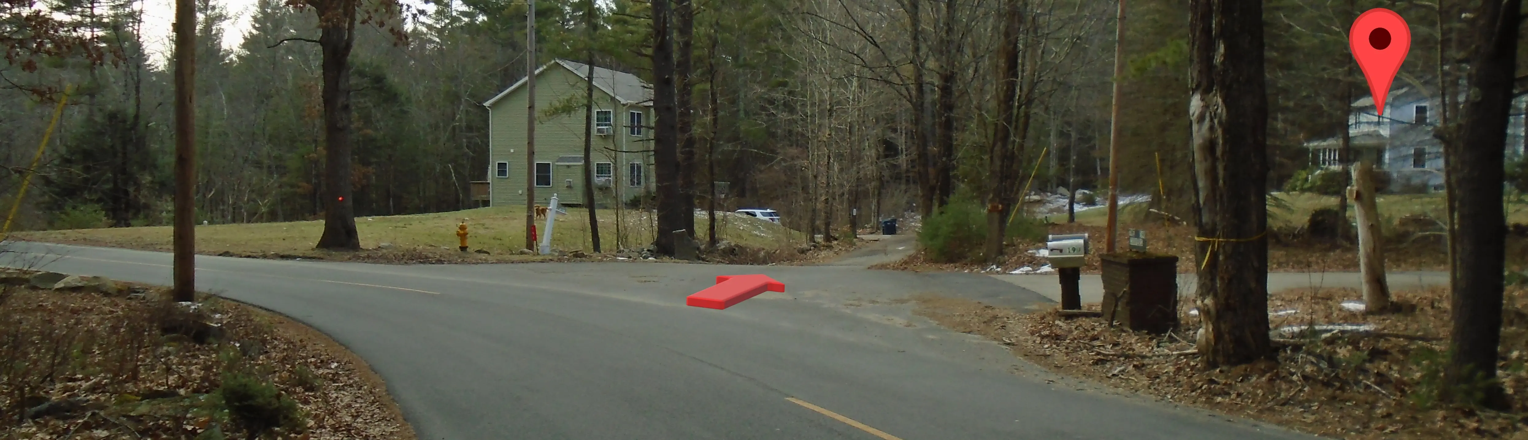
- After 1¾ miles, the road will go over a hill and then turn gradually left. There will be mailboxes by a brick-based sign stating “The Coopers”. The main road turns to the left, the driveway for my brother’s family is to the right, and you bear slightly right for the road to get to our house. You may be able to see the blue house on the right side from there.
From the south & west
- From the west, take I-90 (Mass. Pike) East to Exit 78 (old Exit 9) onto I-84 West. Or, from the southwest, take I-84 East.
- On I-84, take Exit 6A (old Exit 3A) onto Rte. 20 East.
- Continue on Rte. 20 East past the traffic light for the Center at Hobbs Brook shopping plaza, and the traffic light for the junction with Rte. 49.
- After the junction with Rte. 49, continue 1¾ miles and then turn right onto Sampson Rd. There is a sign at the intersection for Heritage Country Club. As some additional landmarks, the road is across from a brick building with address 144 Sturbridge Road, and it is immediately before mile marker 98. If you pass Tree House Brewery, you went just a little too far. (Though rather than turning around, you could instead continue for another mile and a half, turn right onto Rte. 169, and follow the directions above from the turn onto Rte. 169.)
- Sampson Rd. becomes Hill Rd. as you pass the golf course, although you probably won’t notice.
- Take the only left after the golf course onto Ten Schoolhouse Rd.
- At the end of Ten Schoolhouse Rd., turn right onto Berry Corner Rd.
- After about half a mile, the road will go over a hill and then turn gradually left. There will be mailboxes mailboxes by a brick-based sign stating “The Coopers”. The main road turns to the left, the driveway for my brother’s family is to the right, and you bear slightly right for the road to get to our house. You may be able to see the blue house on the right side from there.
Taking back roads from Webster, Dudley, or Southbridge
Depending on where you’re coming from, it may make more sense for you to take this “back way” via Southbridge. It’s not really shown on the maps below, however.
- From Webster and Dudley, take Rte. 12 South.
- Stay straight to go onto Rte. 197.
- After entering Thompson, CT, turn right at the next light onto Rte. 131 to get back into Massachusetts.
- Stay on Rte. 131 through Southbridge to the rotary.
- Go around the rotary most of the way to stay on Rte. 131, which becomes Main St. here.
- Go a little over a mile on Main St. and turn right onto Pleasant St.
- After passing by the airport, the road takes an abrupt left and down onto Ayers Rd. You don’t really have a choice here.
- Continue on Ayers Rd. about half a mile.
- When the road turns to the right, with a driveway ahead, take a sharp left instead.
- Our blue house is directly on the right side of that road.
Area map
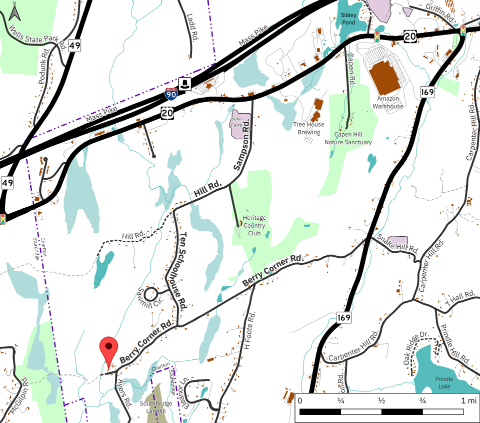
Map data © OpenStreetMap contributors.
Detail map of destination
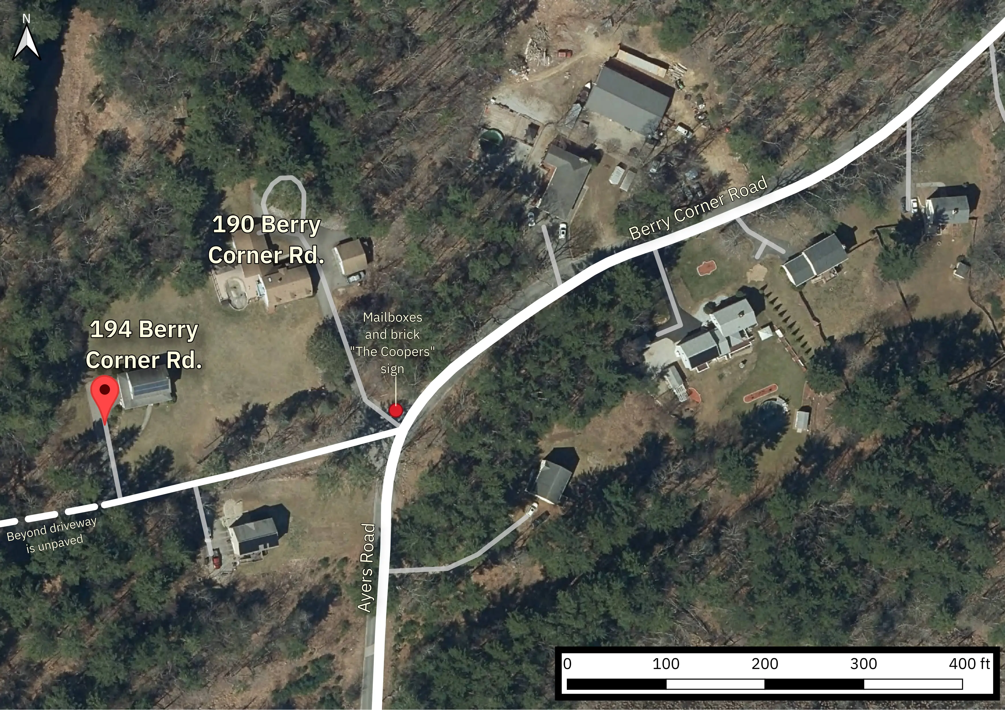
Aerial Imagery from MassGIS (Bureau of Geographic Information), Commonwealth of Massachusetts EOTSS.
Map data © OpenStreetMap contributors.
View of house & going onto road